[arXiv PrePrint]
![Scenes rendered per \(512^2\) environment maps. [Centre] Our DNN sky-model (Fig.\(\textcolor{red}{b}\), per \(\textcolor{red}{R}\textcolor{green}{G}\textcolor{blue}{B}\)-Icarus with Robertson fusion) recreates the illumination, tones and light transmission of real-world Full Dynamic Range imagery (\(\textit{FDR}\) ground truth in Fig.\(\textcolor{red}{a}\)). Icarus accurately models solar illumination for unprecedented lighting directionality (shadows, Fig.\(\textcolor{red}{c}\)). [Border] Icarus enables intuitive user-control over positioning and styling of solar and atmospheric formations.](/deep_sky/icarus/icarus_header.png)
Icarus
Scenes rendered per \(512^2\) environment maps. [Centre] Our DNN sky-model (Fig.\(\textcolor{red}{b}\), per \(\textcolor{red}{R}\textcolor{green}{G}\textcolor{blue}{B}\)-Icarus with Robertson fusion) recreates the illumination, tones and light transmission of real-world Full Dynamic Range imagery (\(\textit{FDR}\) ground truth in Fig.\(\textcolor{red}{a}\)). Icarus accurately models solar illumination for unprecedented lighting directionality (shadows, Fig.\(\textcolor{red}{c}\)). [Border] Icarus enables intuitive user-control over positioning and styling of solar and atmospheric formations.
Abstract
Accurate environment maps are a key component to modelling real-world outdoor scenes. They enable captivating visual arts, immersive virtual reality and a wide range of scientific and engineering applications. To alleviate the burden of physical-capture, physically-simulation and volumetric rendering, sky-models have been proposed as fast, flexible, and cost-saving alternatives. In recent years, sky-models have been extended through deep learning to be more comprehensive and inclusive of cloud formations, but recent work has demonstrated these models fall short in faithfully recreating accurate and photorealistic natural skies. Particularly at higher resolutions, DNN sky-models struggle to accurately model the 14EV+ class-imbalanced solar region, resulting in poor visual quality and scenes illuminated with skewed light transmission, shadows and tones. In this work, we propose Icarus, an all-weather sky-model capable of learning the exposure range of Full Dynamic Range (FDR) physically captured outdoor imagery. Our model demonstrates conditional multi-exposure image environment map generation with intuitive user-positioning of solar and cloud formations, extending the current state-of-the-art to user-controlled texturing of atmospheric formations. Through our evaluation, we demonstrate Icarus is interchangeable with FDR physically captured outdoor imagery or parametric sky-models, and illuminates scenes with unprecedented accuracy, photorealism, lighting directionality (shadows), and tones in Image Based Lighting (IBL).
Related Work
This work is part of the broader Deep Sky initiative, which explores neural approaches to photorealistic sky modeling with user control over environmental parameters.
Methodology
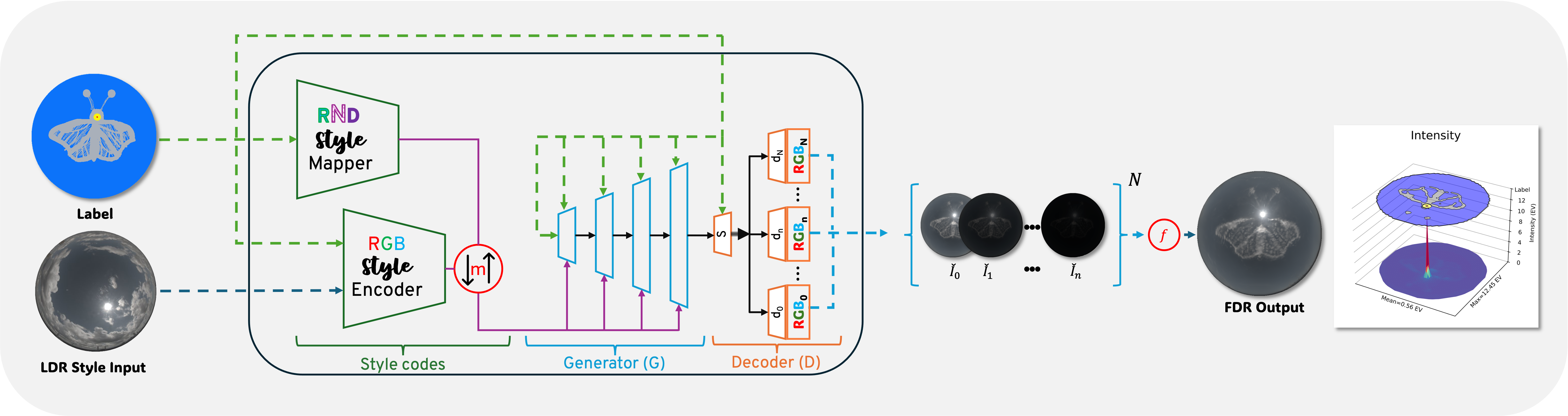
In this work, we propose a novel multi-exposure approach to sky-modelling which enables the generation of high-resolution Full Dynamic Range (FDR) environment maps with real-world atmospheric stochasticity. We achieve this through the following contributions:
- A method for decomposing HDRI to LDR exposure brackets, alleviating explicit requirements for tone mapping operators.
- A method for synchronous generation of exposures.
- A method to train which accounts for per-exposure feature variability and continuity between exposures.
- A method for post-generation fusion to FDR.
Where previous works have struggled with aggressive tone-mapping operators, clear-sky augmentation, and solar spectrum mitigation techniques, we demonstrate an all-encompassing DNN architecture capable of modeling FDR physically captured outdoor imagery. We show our method can be scaled to a resolution of \(512^2\), enabling generated environment maps to provide a real-world solar disk size of \(0.5^\circ\) angular diameter with real-world 14EV+ intensity in downstream applications.
What can Icarus do?
Our implementation of Icarus is capable of generating high-resolution Full Dynamic Range (FDR) environment maps with real-world atmospheric stochasticity, enabling accurate and photorealistic outdoor lighting for Image Based Lighting (IBL) applications. Through our evaluation, we demonstrate Icarus is interchangeable with FDR physically captured outdoor imagery and parametric sky-models, and illuminates scenes with unprecedented accuracy, photorealism, lighting directionality (shadows), and tones.
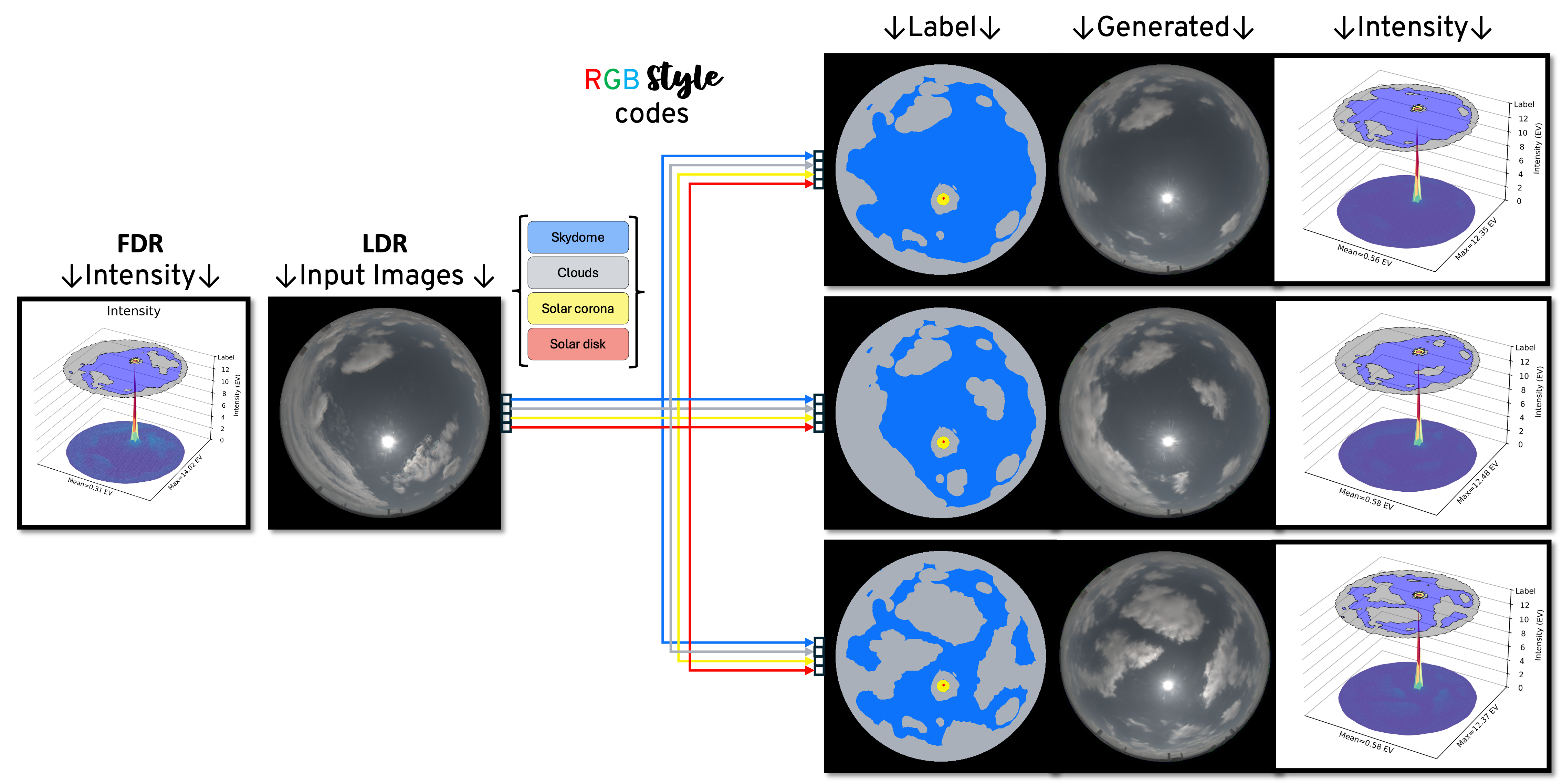
Augmentation to FDR and FDR Environment Map Generation
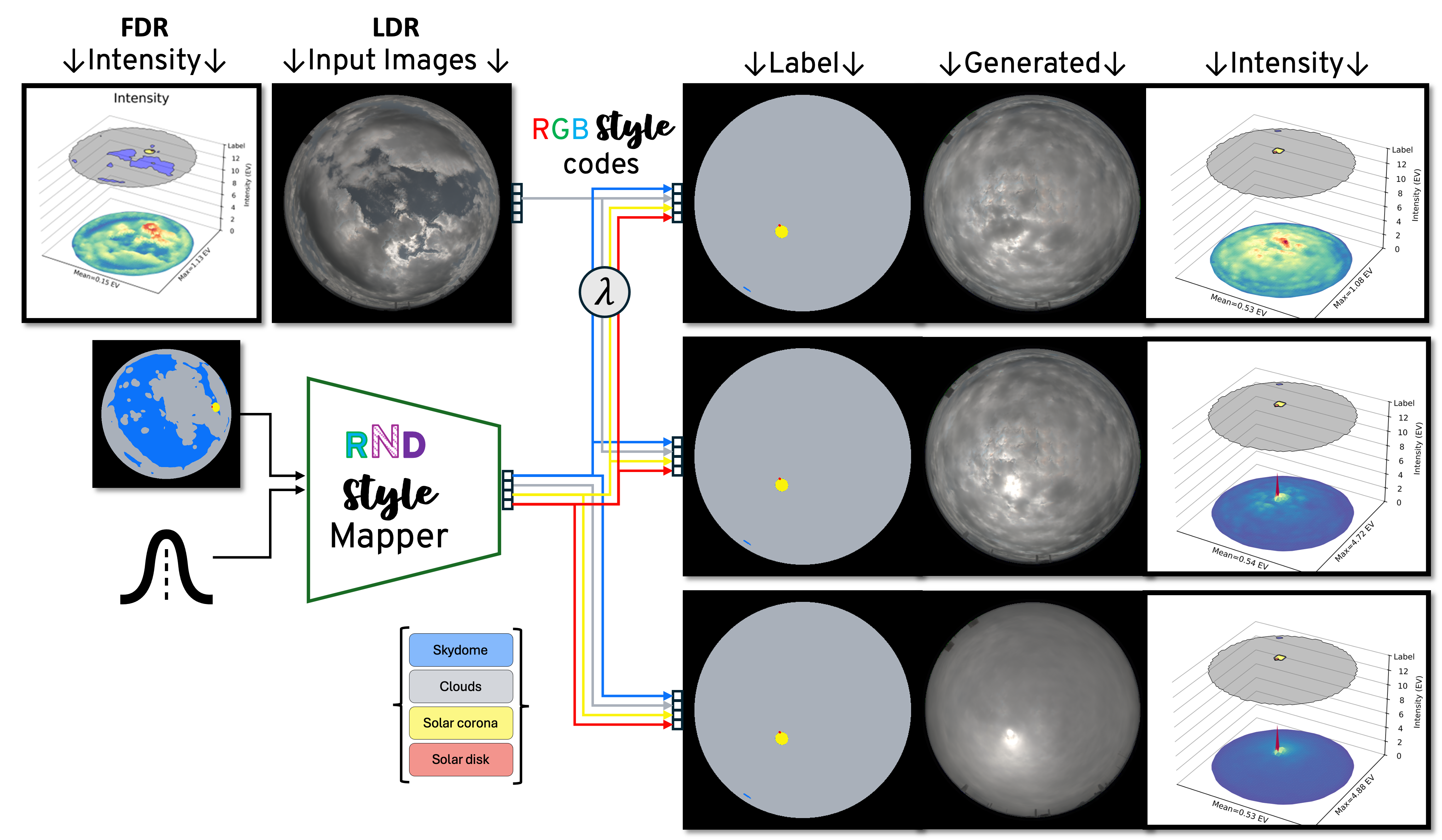
Icarus enables artists to generate FDR environment maps with intuitive user-positioning of solar and cloud formations.
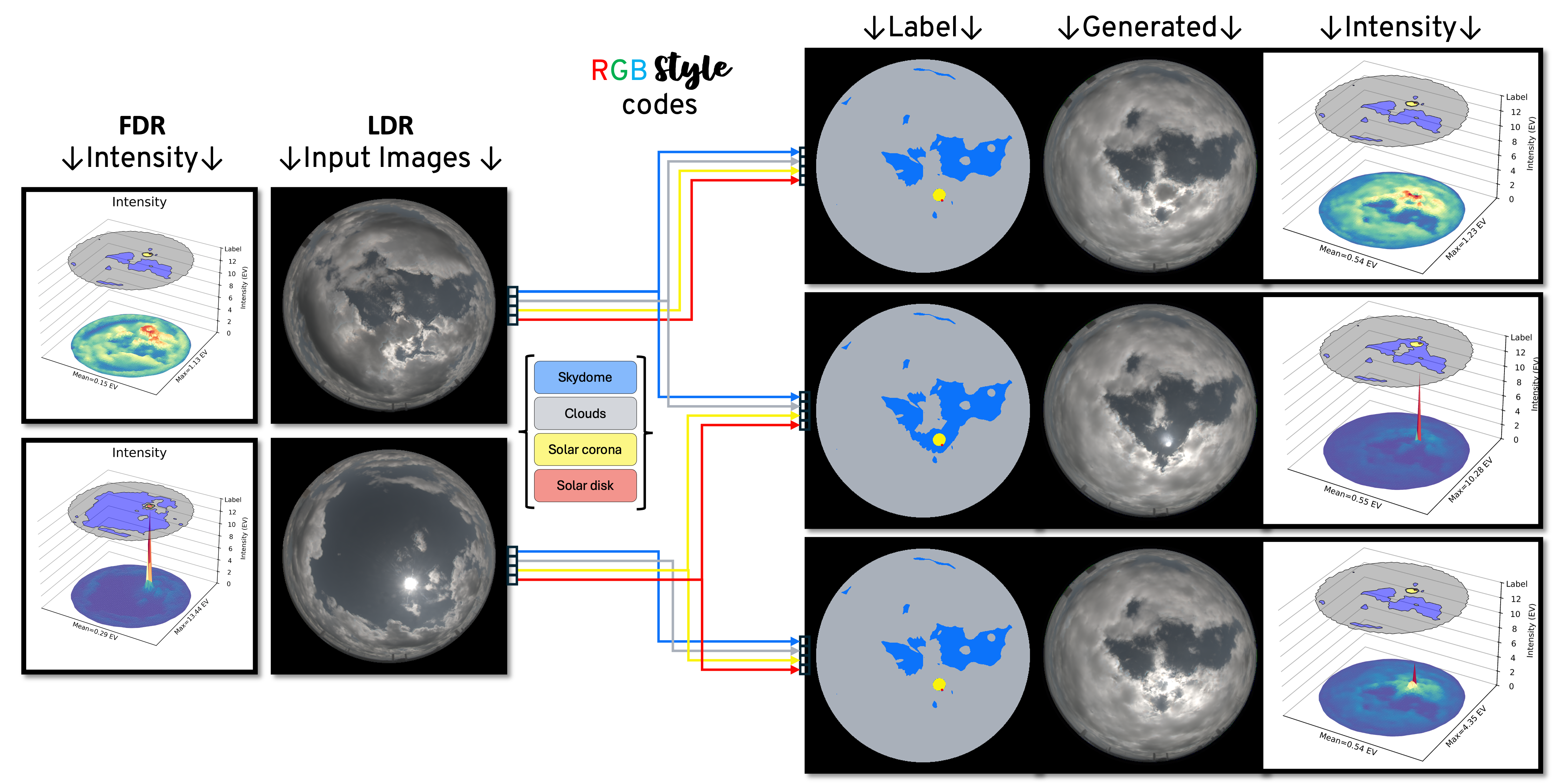
* The \(\textcolor{red}{R}\textcolor{green}{G}\textcolor{blue}{B}\)-Style encoder enables users to select styles from LDR source image(s) to transfer to custom FDR environment maps. If all styles are selected from a singular LDR source image, Icarus functions as an LDR-to-FDR augmentation mechanism!
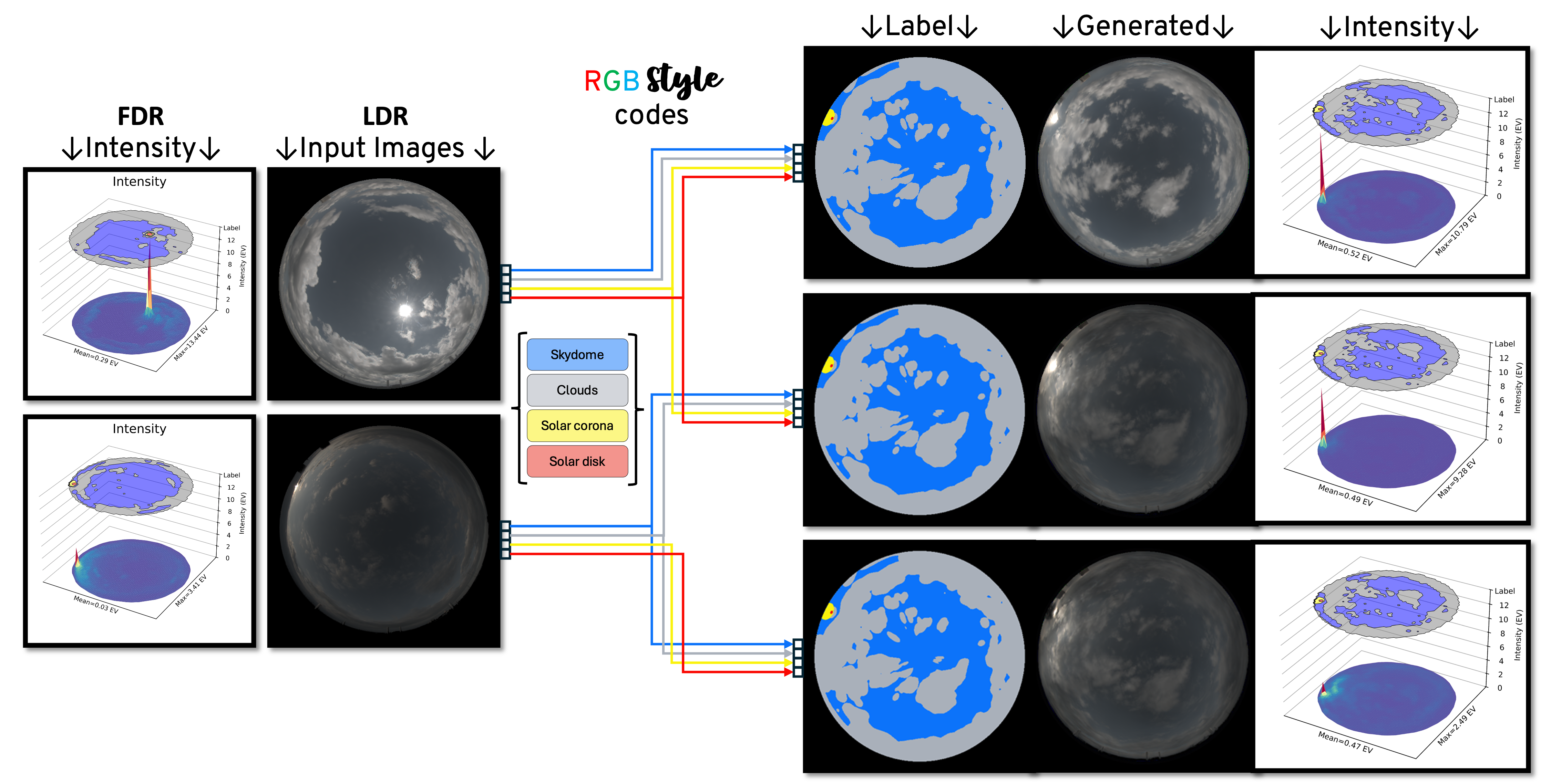
* When no specific style is desired, the \(\textcolor{blue}{R}\textcolor{magenta}{N}\textcolor{violet}{D}\)-Style mapper guides style generation towards textures which will coherently integrate into the environment map’s structure (e.g. mitigating the generation of incompatible clear-sky sun styles with overcast cloud styles).
Styles codes from either or both the \(\textcolor{red}{R}\textcolor{green}{G}\textcolor{blue}{B}\)-Style encoder and \(\textcolor{blue}{R}\textcolor{magenta}{N}\textcolor{violet}{D}\)-Style mapper can be user-selected from one or multiple runs to generate a latent image
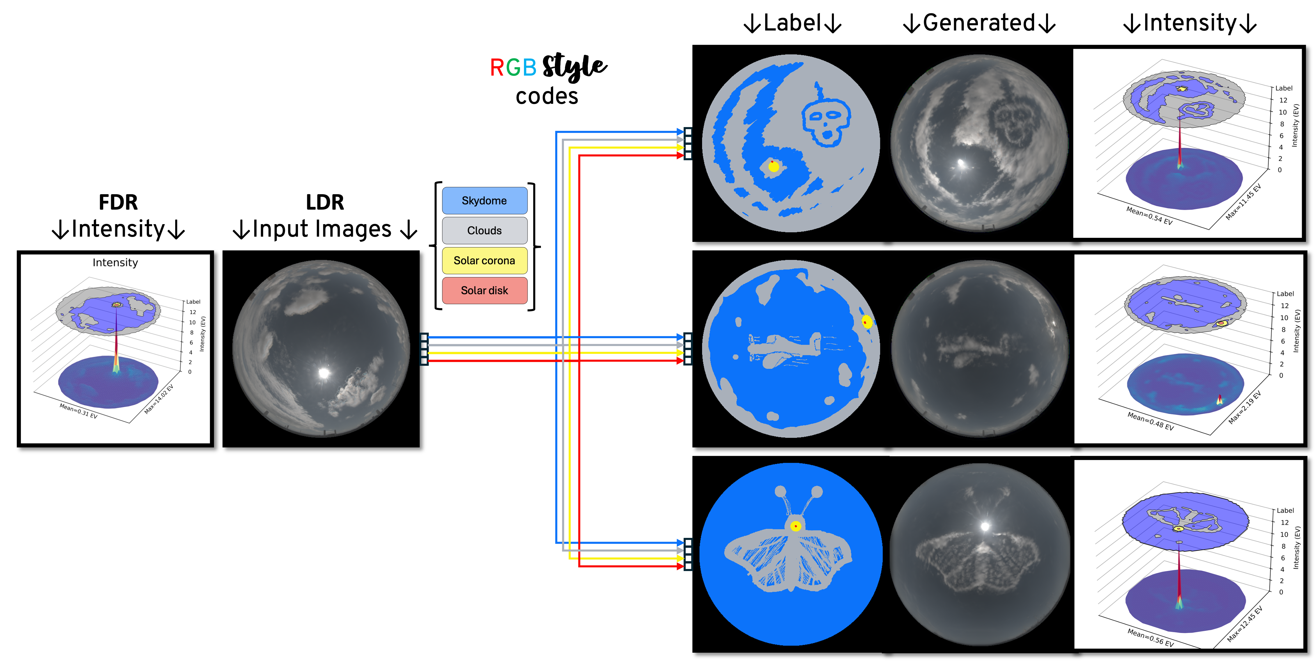
Creative Examples
The styles of a source image can be used to create surreal skies. Icarus \(512^2\) with \(\textcolor{red}{R}\textcolor{green}{G}\textcolor{blue}{B}\)-styles and Robertson fusion.
Creative Examples
The styles of a source image can be used to create surreal skies. Icarus \(512^2\) with \(\textcolor{red}{R}\textcolor{green}{G}\textcolor{blue}{B}\)-styles and Robertson fusion.
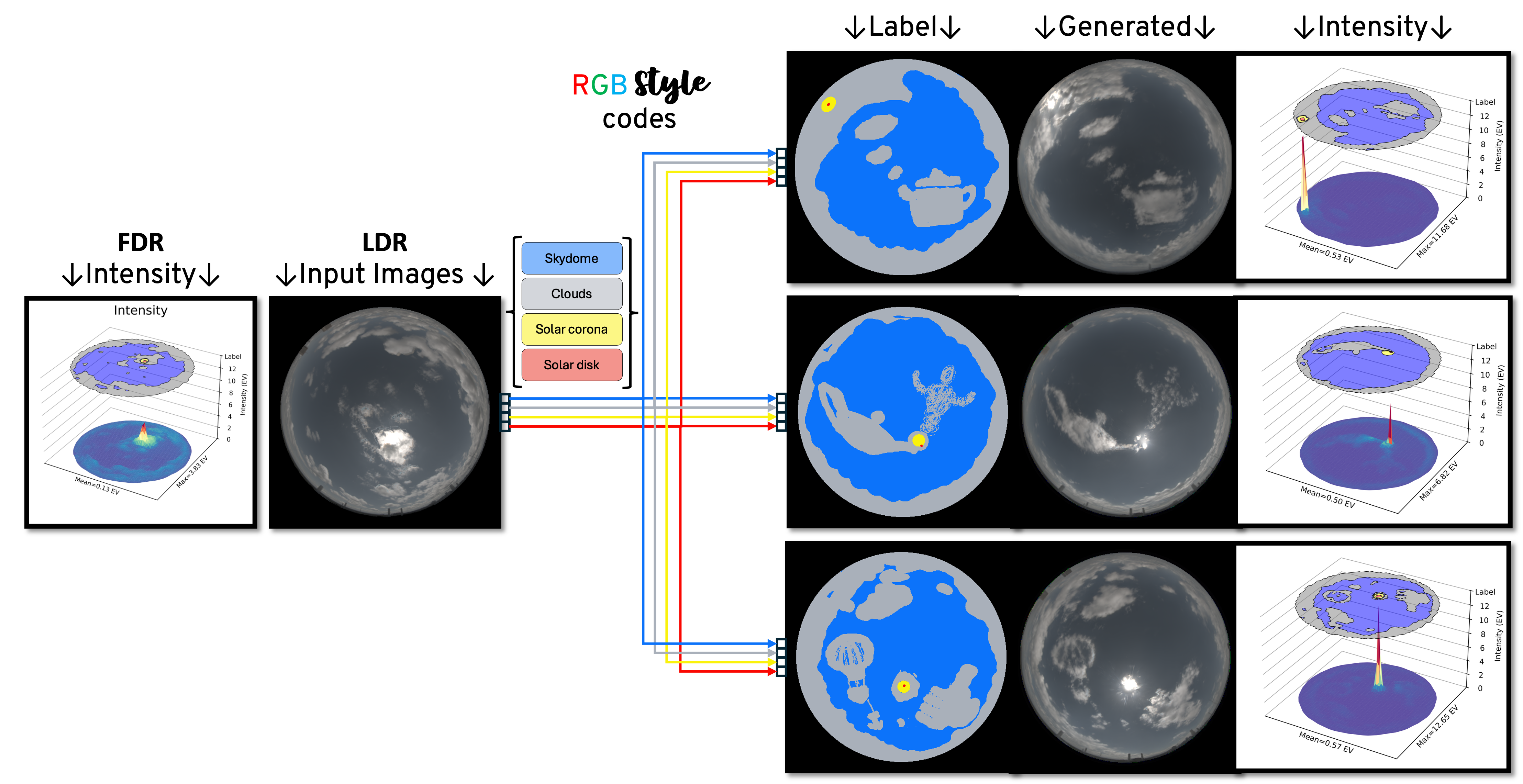
Creative Examples
Icarus supports mixing of \(\textcolor{red}{R}\textcolor{green}{G}\textcolor{blue}{B}\)- and \(\textcolor{blue}{R}\textcolor{magenta}{N}\textcolor{violet}{D}\)-styles in creating environment maps. Icarus \(512^2\) with \(\textcolor{red}{R}\textcolor{green}{G}\textcolor{blue}{B}\)-styles, \(\textcolor{blue}{R}\textcolor{magenta}{N}\textcolor{violet}{D}\)-styles and Robertson fusion.
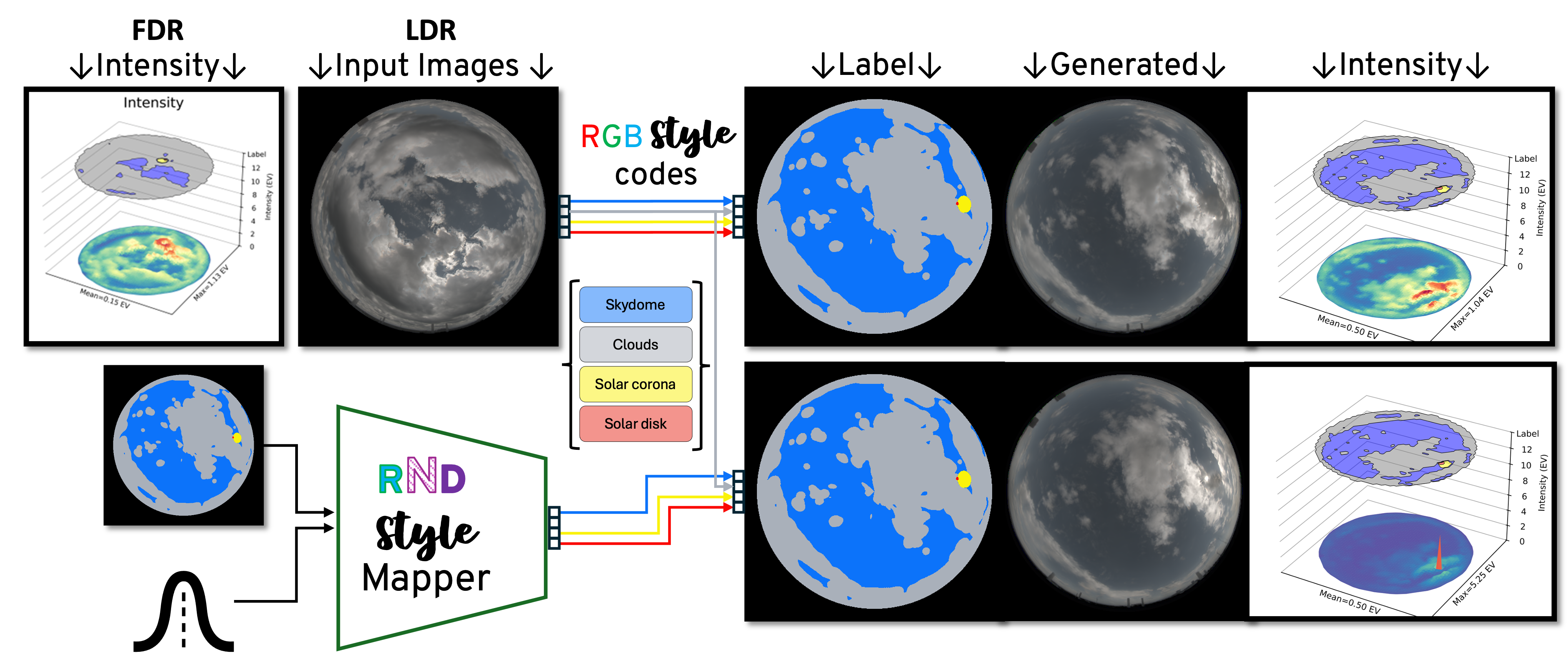
Creative Examples
Icarus supports weighted mixing of \(\textcolor{red}{R}\textcolor{green}{G}\textcolor{blue}{B}\)- and \(\textcolor{blue}{R}\textcolor{magenta}{N}\textcolor{violet}{D}\)-styles to creating customized environment maps. As depicted by \(\lambda\), the weights of styles can be user-modulated to emphasize or subdue selected styles. The weights of solar features were reduced to create a more uniform overcast sky. Icarus \(512^2\) with \(\textcolor{red}{R}\textcolor{green}{G}\textcolor{blue}{B}\)-styles, \(\textcolor{blue}{R}\textcolor{magenta}{N}\textcolor{violet}{D}\)-styles and Robertson fusion.
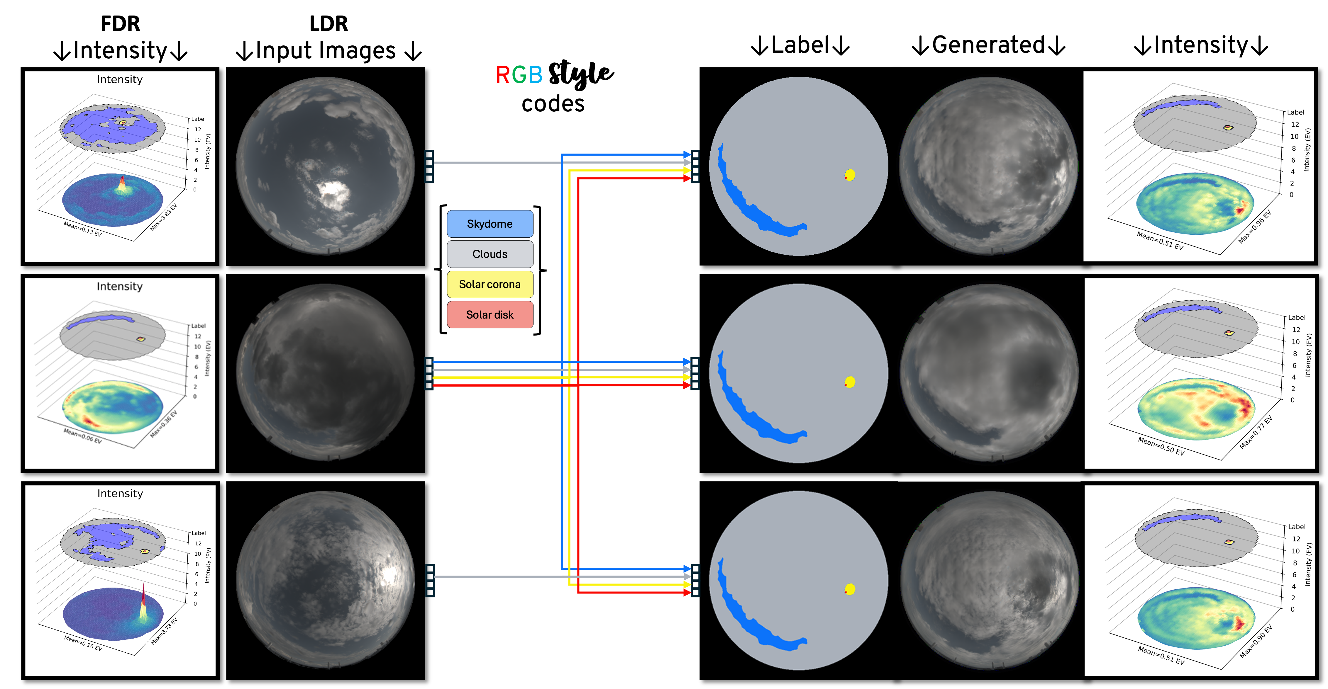
Transferring solar illumination
An obfuscated sun (top row) can be un-obfuscated (middle row) or brightened (bottom row) by transferring the style of solar corona and solar disk from a preferable source image.
Accurate and Photorealistic Illumination
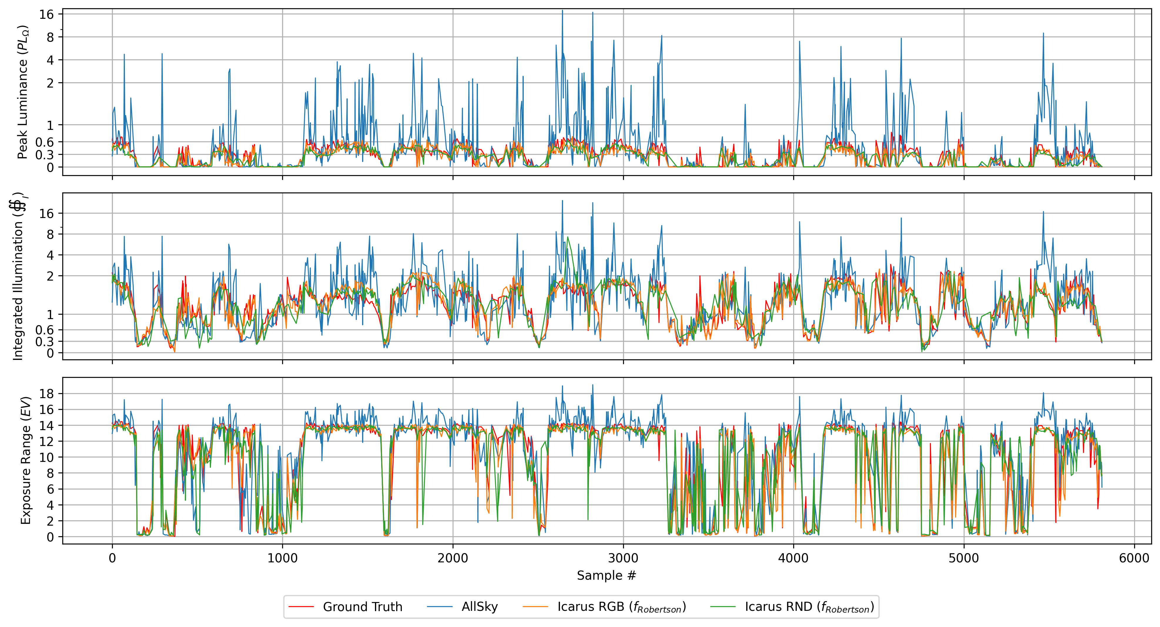
As demonstrated in the figures below, mitigation strategies exhibit limited generalization to the four primary sky configurations: clear, cloudy, cloudy with overcast sun and overcast skies. Though results can be visually appealing, emulating atmospheric attenuation for reliable luminance in downstream applications remains a challenge only addressed by AllSky and Icarus. That being said, Icarus supersedes Allsky in photorealism, accuracy and stability. As shown in Figure stability, Icarus offer stability in illumination with \(66\times\) less linear-space exposure range variance.
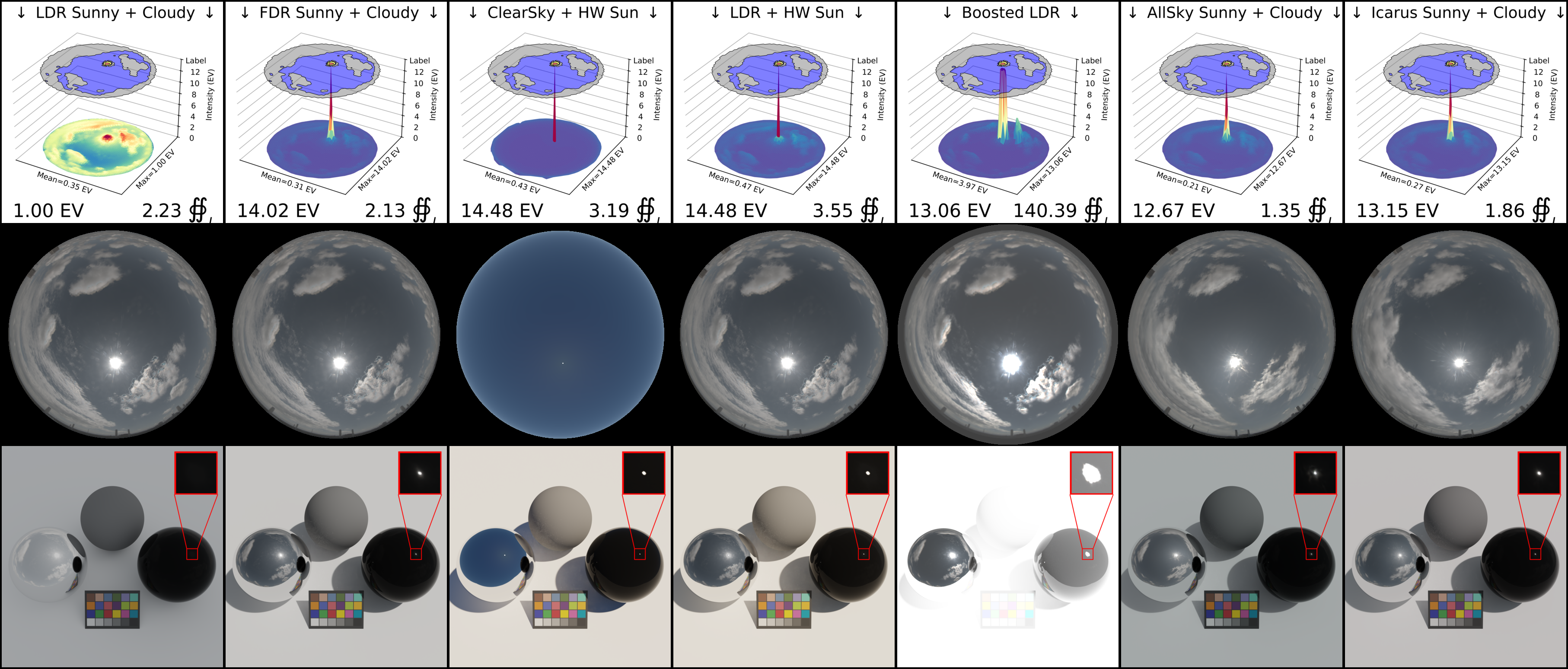
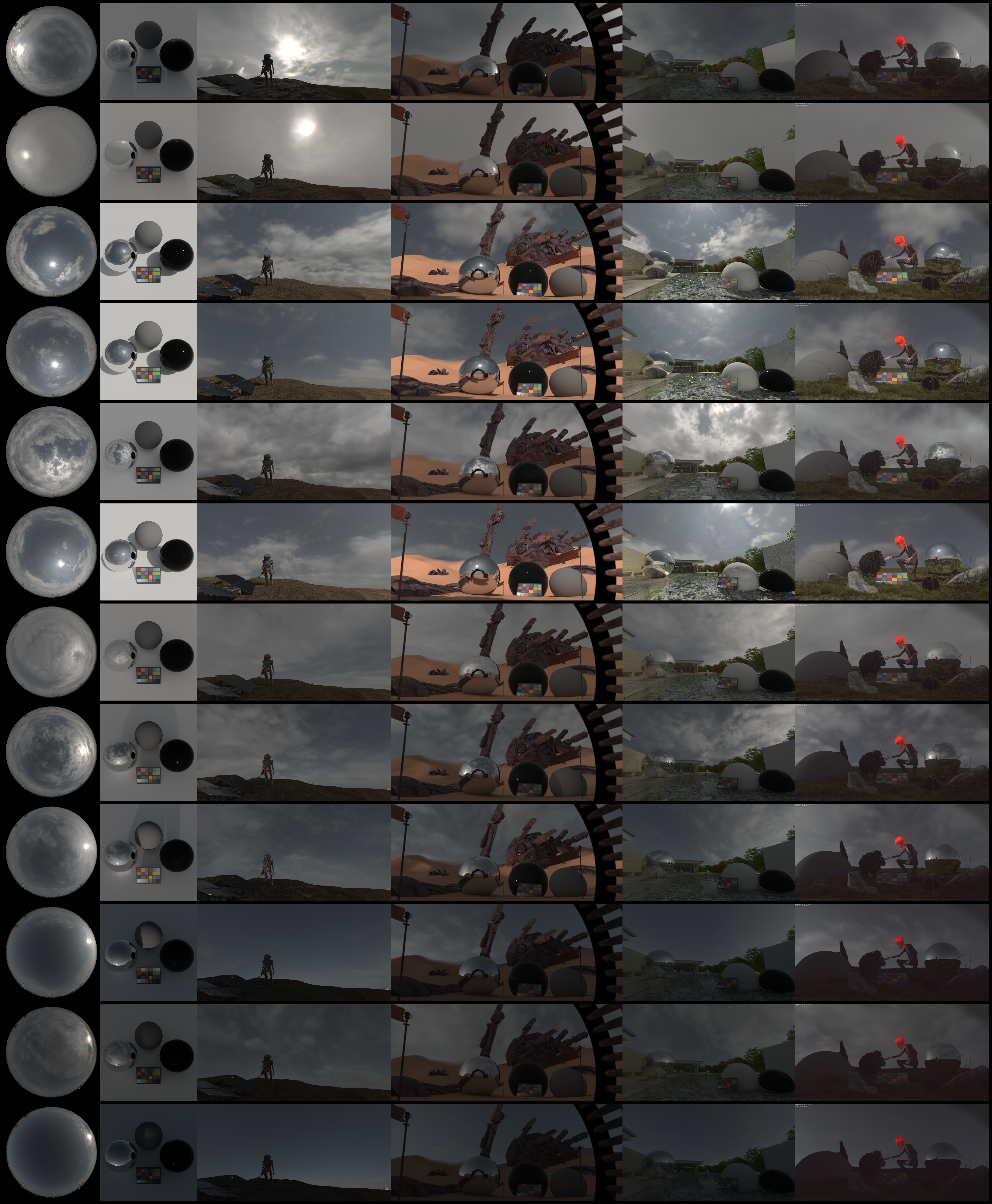
Cloudy with unobstructed sun
Mitigation of solar modelling in environment maps through Deep Clouds' substitution of a parametric Hošek-Wilkie (HW) sun and Text2Light's manual parametric boosting of the HDR environment map (Boosted;\(\gamma\)=0.5,\(\beta\)=2,\(\rho\)=6). When the sun is unobstructed, adding an HW sun creates crisp shadows, realistic light-transmission (black glass orb) and only minor alteration of perceived tones (lambertian surface, color chart). Boosting an HDR image is subjective to user-selection of parameters, which drives both the algorithms' selection of features and enhancement of intensity. Boosting is prone to over-exposing rendered scenes, producing unpredictable shadows, excessive light-transmission (black glass orb), and severe alteration of perceived tones (lambertian planar surface and color chart). While Allsky mitigates the skewed tones from the parametric sun and over-saturation of boosting, Icarus (right column) offers greater photorealism and accuracy in illumination (EV and \(\oiint_I\)).
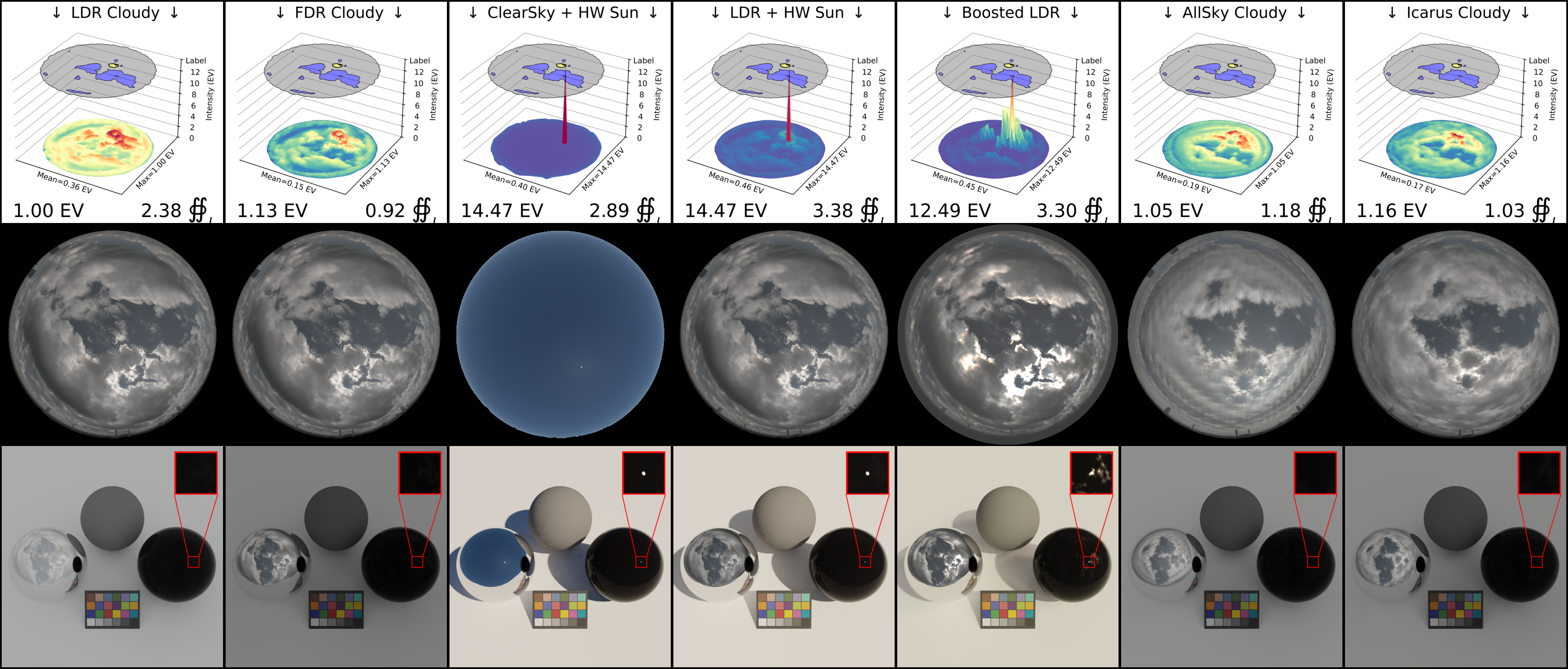
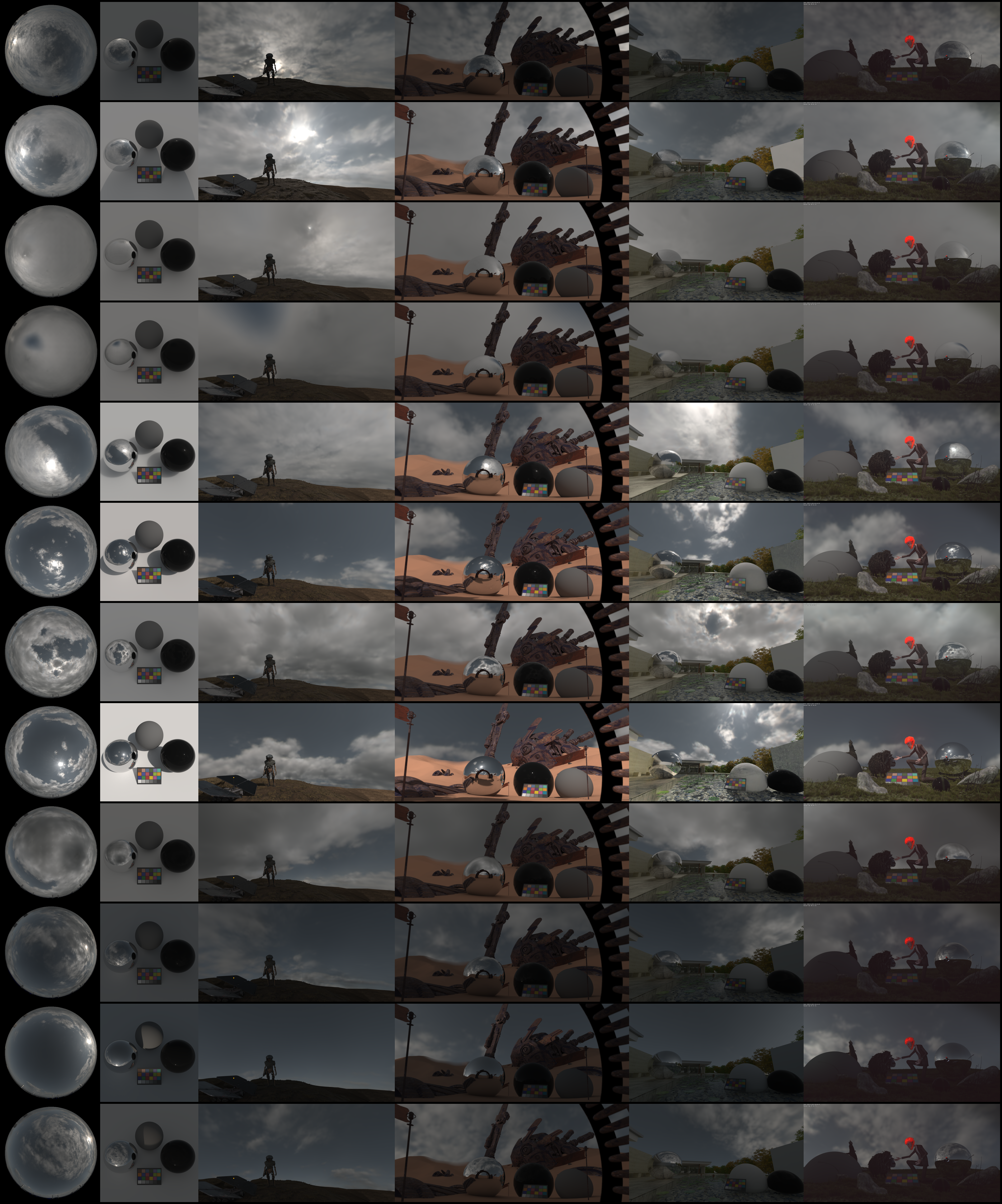
Cloudy with obstructed sun
Mitigation of solar modelling in environment maps through Deep Clouds' substitution of a parametric Hošek-Wilkie (HW) sun and Text2Light's manual parametric boosting of the HDR environment map (Boosted;\(\gamma\)=0.5,\(\beta\)=2,\(\rho\)=6). Adding an HW sun skips atmospheric attenuation and allows the sun to `pierce' through clouds to create strong shadows and unexpected light-transmission (black glass orb). If the sun is obstructed, boosting is prone to over-exposing (see skydome in \(2^{nd}\)row and light-transmission to black-glass orb), producing unpredictable shadows and excessive light-transmission (black glass orb). Allsky and Icarus both mitigate alteration of perceived tones (lambertian planar surface and color chart), with Icarus (right column) offering greater photorealism and accuracy in illumination (EV and \(\oiint_I\)).
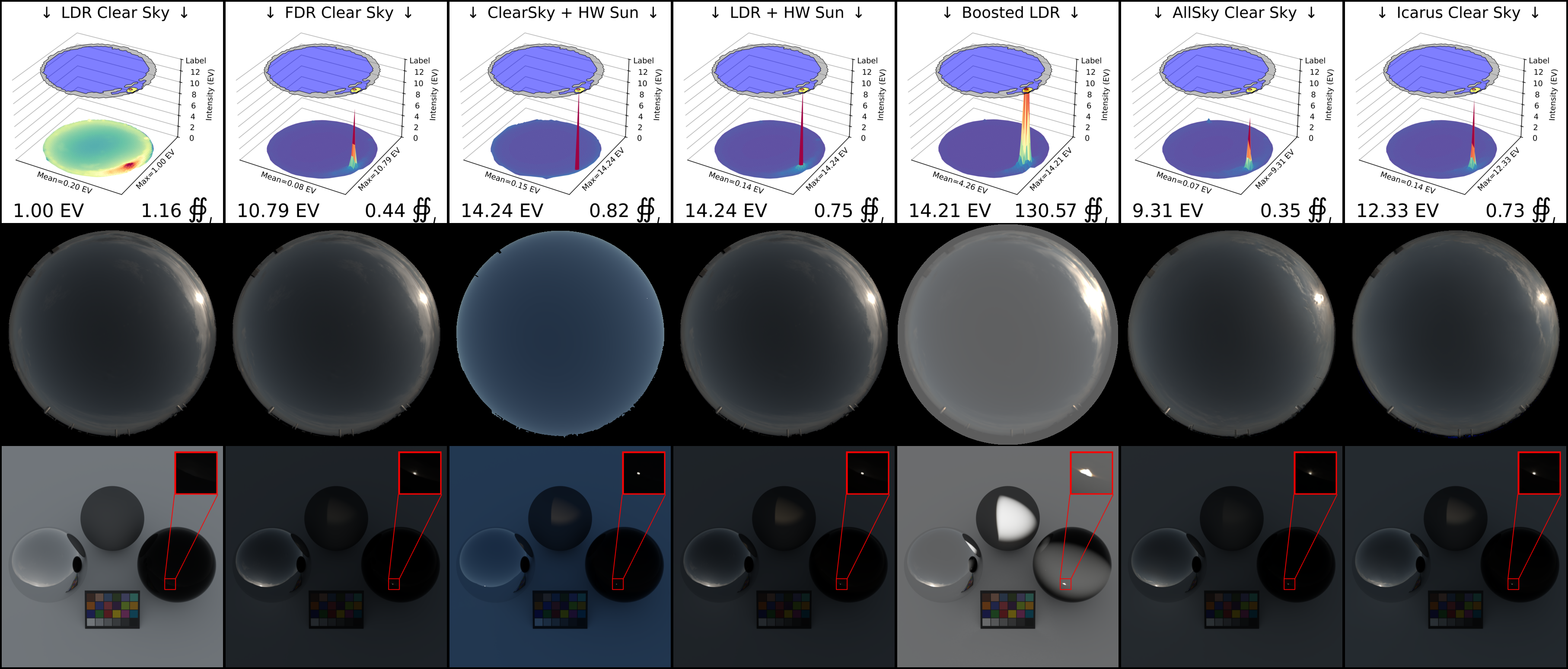
Clear sky
Mitigation of solar modelling in environment maps through Deep Clouds' substitution of a parametric Hošek-Wilkie (HW) sun and Text2Light's manual parametric boosting of the HDR environment map (Boosted;\(\gamma\)=0.5,\(\beta\)=2,\(\rho\)=6). In low-light settings such as dusk/sunset/sunrise, adding a parametric sun can be difficult given minor errors in camera calibration. Though an added HW sun `pierces' through clouds formations with\(10.9\!\times\)linear intensity of ground truth \(\textit{FDR Clear sky}\), the absence of clouds acting as light-sources allows for relatively-indirect HW solar illumination to produce visually appealing renders without skewed tones. Boosting is subjective to user-selection of parameters driving the algorithms' selection of features, which in low-light settings is shown to be prone to over-exposing the entirety of the skydome. This over-exposure results in unpredictable shadows (lambertian orb), excessive light-transmission (black glass orb) and altered tones (lambertian planar surface and color chart). Allsky and Icarus both mitigate alteration of perceived tones (lambertian planar surface and color chart), producing renderings with accurate tones, shadows and light transmission.
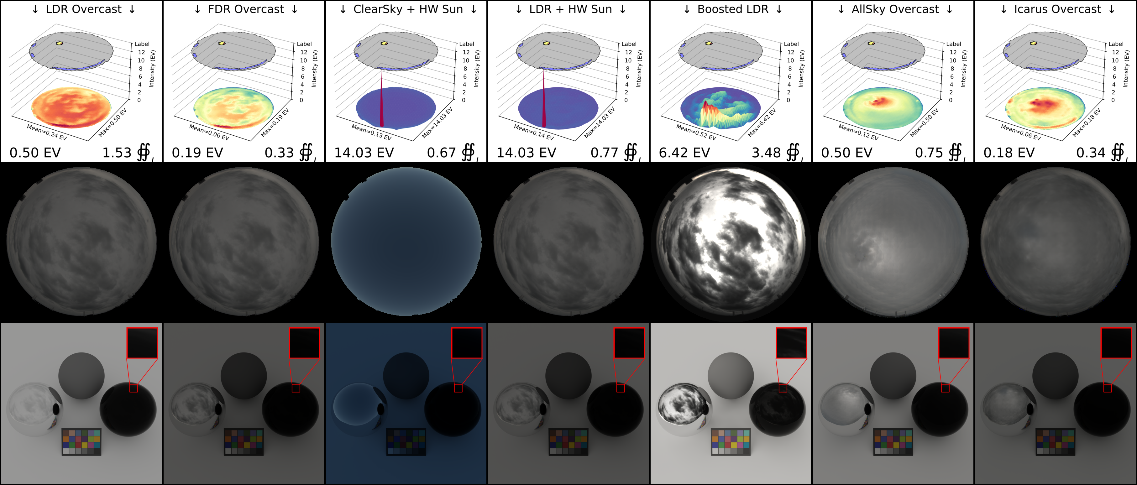
Overcast sky
Mitigation of solar modelling in environment maps through Deep Clouds' substitution of a parametric Hošek-Wilkie (HW) sun and Text2Light's manual parametric boosting of the HDR environment map (Boosted;\(\gamma\)=0.5,\(\beta\)=2,\(\rho\)=6). Adding an HW sun (\(\textit{LDR+HW Sun}\)) skips atmospheric attenuation and allows the sun to `pierce' through clouds to create strong shadows. If the sun is obstructed, Boosting an HDR image (\(\textit{Boosted LDR}\)) is prone to over-exposing and producing unpredictable shadows. Both mitigation strategies alter the perceived tones in IBL renderings (lambertian planar surface and color chart), but AllSky and our model (Icarus, right column) accurately model real-world FDR illumination for photorealistic IBL renderings.
Environment Map Editing
What if you have a cloud formation that you like, but the sun is obscured? Or a sunset with a beautiful sun, but you want to add some clouds? Icarus enables intuitive user-control over positioning and styling of solar and atmospheric formations, allowing artists to edit environment maps in an intuitive manner.
Citation
@article{Maquignaz2026Icarus,
  title={Full Dynamic Range Sky-Modelling For Image Based Lighting},
  author={Maquignaz, Ian J.},
  journal={arXiv preprint arXiv:2603.05758},
  year={2026}
}
Gallery
Icarus \(\textcolor{red}{R}\textcolor{green}{G}\textcolor{blue}{B}\)-Style
Collection of environment maps generated by Icarus with \(\textcolor{red}{R}\textcolor{green}{G}\textcolor{blue}{B}\)-style encoder and Robertson fusion, demonstrating IBL rendering performance from sunrise to sunset.
Icarus \(\textcolor{blue}{R}\textcolor{magenta}{N}\textcolor{violet}{D}\)-Style
Collection of environment maps generated by Icarus with \(\textcolor{blue}{R}\textcolor{magenta}{N}\textcolor{violet}{D}\)-style mapper and Robertson fusion, demonstrating IBL rendering performance from sunrise to sunset.
References
Maquignaz, Ian J. “Towards Physically-Based Sky-Modeling For Image Based Lighting.” 2026 International Conference on 3D Vision (3DV). IEEE, 2026. ↩︎
Lukáš Hošek and Alexander Wilkie. 2013. Adding a Solar-Radiance Function to the Hošek-Wilkie Skylight Model. IEEE Computer Graphics and Applications 33, 3 (2013),44–52. doi:10.1109/MCG.2013.18 ↩︎
Pinar Satilmis, Demetris Marnerides, Kurt Debattista, and Thomas Bashford-Rogers. Deep synthesis of cloud lighting. IEEE Computer Graphics and Applications, 2022. ↩︎
Mirbauer, M., Rittig, T., Iser, T., Křivánek, J. and Šikudová, E. (2024), SkyGAN: Realistic Cloud Imagery for Image-based Lighting. Computer Graphics Forum, 43: e14990. ↩︎
Chen, Zhaoxi, Guangcong Wang, and Ziwei Liu. “Text2light: Zero-shot text-driven hdr panorama generation.” ACM Transactions on Graphics (TOG) 41.6 (2022): 1-16. ↩︎